
When people think of Busan, they often think of sunny days at the beach and taking a dip in the ocean. The mountains around the city tend to be overlooked and people don’t realize that there happens to be some great hiking in Busan as well! And you know me, I’m a bit obsessive when it comes to exploring and finding the best hikes in Korea – so of course Busan was no exception.
For more awesome things to do in Busan – or info about where to stay – check out my Busan Travel Guide.
The Best Hiking in Busan.
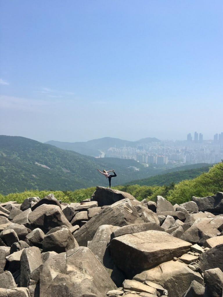
Jangsan
Jangsan is a mountain located in the Haeundae district of Busan. This mountain reaches an elevation of 634 m (2,080 ft) and offers stunning views of the city below. It’s a moderate hike that anyone can do and is fairly easy to get to from the city. It’s quite a pretty place to spend the afternoon lost in nature.
Jangsan Attractions.
- Active landmines: It’s a surreal experience walking through the mountainside among the signs warning of landmines!
- Jangsan Waterfall
- City Views
- Unique Terrain – large rock slides
- Daecheon Park
How to get there.
Map.
Take the metro to Jangsan station and leave out of exit 10. Walk straight ahead for 10-15 mins until you reach Jangsan Daecheon Park. You can find a trail map at the park. It’s very close to Haeundae Beach so you can also take a taxi from here for about 5,000 Won / $4.50 USD.

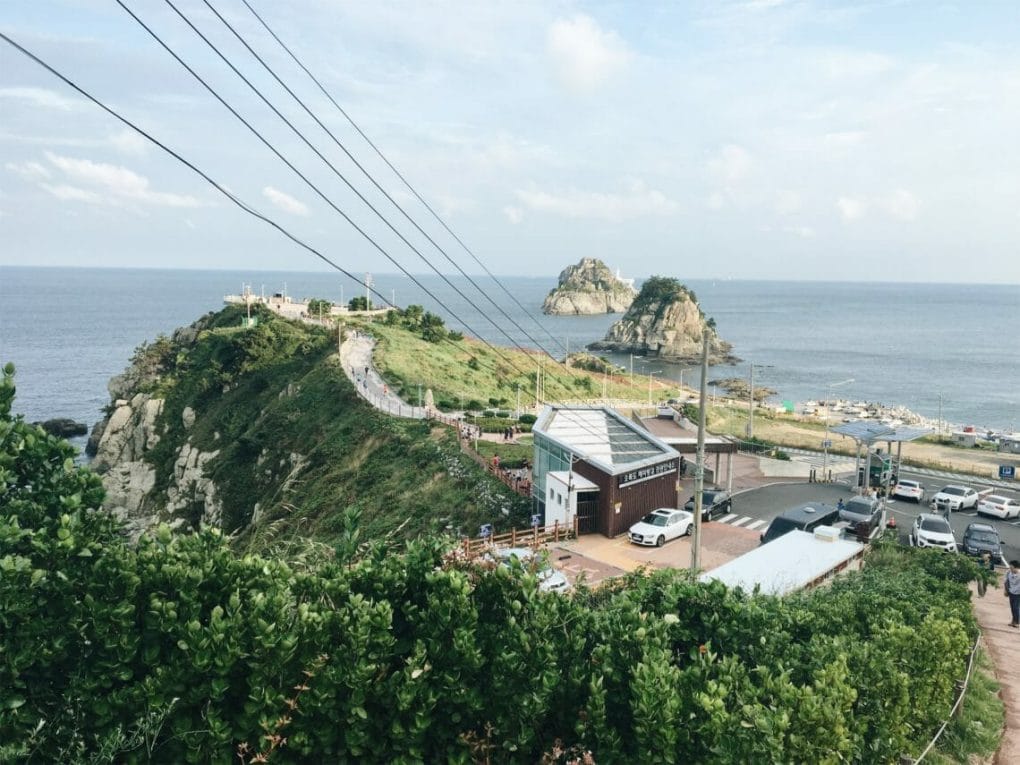
Igidae Coastal Walk – Oryukdo Skywalk
The Igidae Coastal Walk is a linear trail that follows the coastline of the East Sea. You can start from either end – from the Dongseangmal Observatory or Oryukdo Sunrise Park – but I prefer to end at the skywalk. The length of the trail is about 4 km and is essentially flat with a few stair climbs up. The entire trail should take you about 2 hours.
Igidae Attractions.
- City views at northern tip of the park – Dongsaengmal Observatory
- 4 km hiking trail along the coast
- Cliff views
- Nongbawi Rock
- Oryukdo Sunrise Park / Oryukdo Skywalk
For more information, click here.
How to get there.
Map.
Make your way to Namcheon Station. From here, it’s a couple km to the park entrance. Take a taxi (about 5,000 won) or take the 남구2 bus to Bunpo Schools. It takes maybe 10-15 mins to walk to the park and to the start of the trail. After your hike, from Oryukdo Skywalk (오륙도 스카이워크) the 남구2 bus also picks up at this end, or it’s a 15 min (8,000 won) taxi ride to Daeyeon Metro Station.
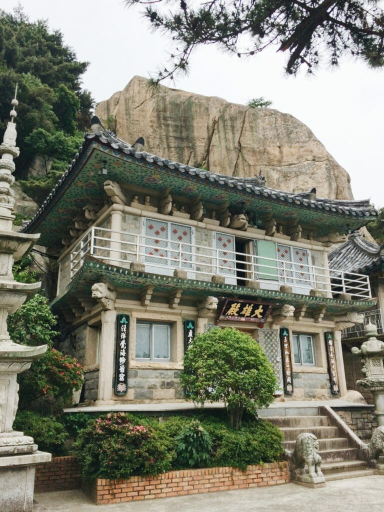
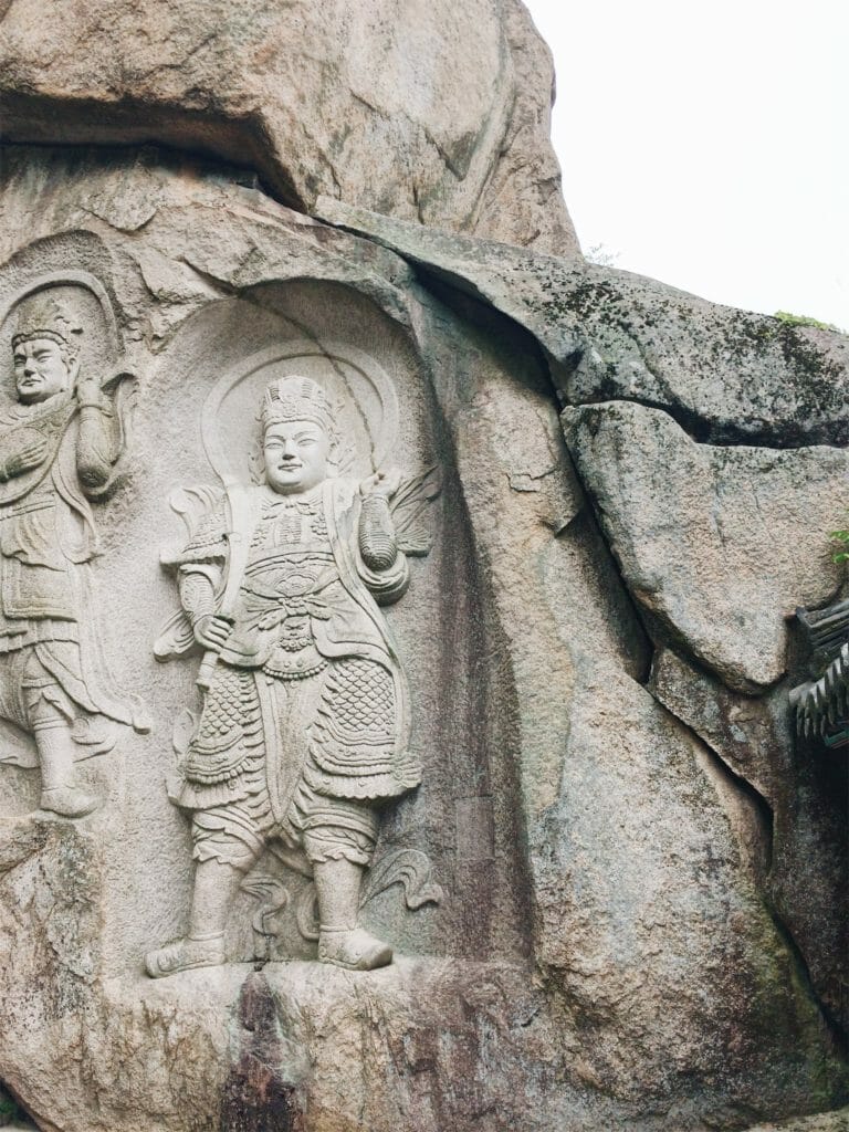
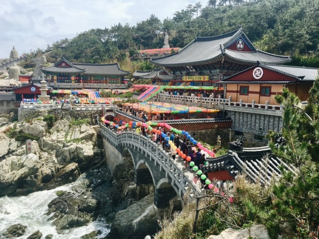
Seokbulsa Temple (석불사)
Although not as popular amongst tourists as Busan’s other main temples, Seokbulsa offers visitors a very unique and secluded experience. Since it is a bit of a hike to get to, Seokbulsa is usually fairly crowd free. The massive stone carved Buddha figures in the mountain are beautiful and the escape to nature is a great day trip from the city.
Seokbulsa Attractions.
- Stone temple with Buddha statues carved into the mountain
- Cable Car
- Nammun Village + restaurants
- City Views
- Ancient city walls and gate
How to get there.
Map.
There are two options.
- Take the metro to Oncheonjang Station and walk 10-ish minutes to get to Geumgang Park and start your hike from here. You can choose to ride the cable car to cut down on the amount of hiking, or hike the extra 2 km (1 hour) to the top.Once at the top, it’s a fairly flat hike to the temple. The trail and signposts can be difficult to find so keep your eyes peeled. It’s easy to get lost. For more information, click here.
- Start at Mandeok Station exit 2 and follow the road all the way up to the temple – it’s about an hour walk. Follow the signs. It’s not the most scenic or pretty walk, but it is the most direct. This is actually the the route many hikers choose to take to descend.
For more information, click here.
Hwangnyeongsan Mountain and Geumnyeonsan Mountain
Hwangnyeongsan (황령산)and Geumnyeonsan (금련산) are twin peaks within the same park. There are countless trails to explore and enjoy and the area is most famous for the cherry blossoms in spring, and the fire beacons on the mountain. This is a popular place to go hiking in Busan.
Hwangnyeongsan and Geumnyeonsan Attractions.
- Variety of hiking trails
- Great city views
- Can hike at night
- Cherry blossoms
- Boardwalks
Click here for more information about Hwangnyeongsan and Geumnyeonsan.
How to get there.
Map.
This park is so large with trails everywhere, so it’s hard to share one exact way to get there. One option is to start at Mulmangol Station and hike across the ridge over to Gwangalli Beach. The green (Geumnyeonsan Station), orange (Yangjeong Station) and brown (Mulmangol Station) lines all border trailheads.

Taejongdae
Taejongdae Park is regarded as one of the most beautiful attractions in Busan. Facing the ocean with views of magnificent cliff ridges, a leisurely hike along the circular trail around the cliff head is a crowd favorite.
Taejongdae Attractions.
- Lighthouse and lookout point
- Several Temples
- Cafes and restaurants at the base
- Highest point at 250 meters
For more information, click here.
How to get there.
Map.
Take the bus to Taejongdae Hot Springs (태종대온천) bust stop. There are eight different buses that stop here. Or take a 25 min, 10,000 won / $9 USD taxi from Nampo Station.
Amnam Park Coastal Walk.
Of course given that Busan is located on the shore and that Koreans love a good hike/coastal stroll, Amnam Park Coastal Walk is just another option to enjoy the jagged cliffs and bright blue waters of the surrounding ocean.
Starting at Songdo Beach and winding south, the trail should take you a few hours to complete if walking the entire length of the coast. It’s an easy stroll with a few inclines. Amnam is one of my favorite places for hiking in Busan.
Amnam Park Attractions.
- Songdo Beach / Songdo Skywalk
- Air Cruise / Cable Car http://www.busanaircruise.co.kr/
- Coastal views
- Pine tree-lined boardwalk trail
- Cliff views
For more information, click here.
How to get there.
Map.
Unfortunately there isn’t a metro stop super near to the start of the park at Songdo Beach – but there are two options.
- You can take the metro to Nampo Station leave out of exit 8. Walk straight about 50 meters / 165 feet toward Yeongdo Bridge. The 7 bus and 9 bus will take you straight to Amnam Park where the trail begins from the parking lot.
- You can also take the 30 or 71 bus to Songdo Beach to first enjoy the skywalk and cable car. From here you can reach the trail at the end of the beach where the pine tree-covered coast begins. Follow the signposts showing the way.

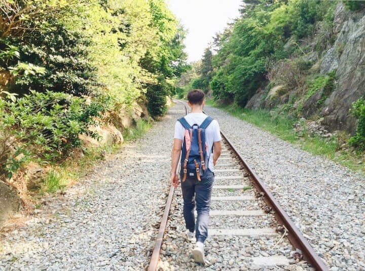
Walk from Haedong Yonggungsa Temple to Haeundae Beach
So this isn’t technically a hike, but it is a long walk (roughly 10+ km / several hours) along the coastline, through a beach or two and on an old railroad track. Starting at Haedong Yonggungsa Temple, it’s possible to follow the shore all the way to Haeundae Beach. There are some pretty cute cafes on this walking trail, making for a chill and leisurely stroll in the sunshine with coffee and cake pit stops along the way.
Haedong Yonggungsa – Haeundae Beach Coastal Walk Attractions.
- Haedong Yonggungsa Water Temple
- Haeundae Beach
- Cheongsapo Daritdol Observatory / skywalk
- Cute cafes for coffee and cake breaks
- Songjeong Beach – where surfers come to catch waves
How to get there:
Map.
After you’ve explored Haedong Yonggungsa Temple, walk back to the entrance and navigate to the parking lot on your left-hand side when looking away from the temple.
At the edge of the parking lot, there’s a forest trail that leads to the ocean. There is a gate marked do not enter in Korean, but just do it anyway. It’s overgrown and grassy but will take you to the shore. You should see a worn-down path where others have walked. Continue following the coast and eventually, you’ll get to a port where there are boats.
From here, there is a large sign and map post marking the walking route. Follow the signs to 송정해수욕장 (Songjeong Beach). You will walk through a small village and winding side roads. After you’ve reached Songjeong Beach walk to the end of the beach and follow the coastal road.
You’ll pass several cafes before eventually turning to go up to the railroad tracks. The turn off is a bit hidden but should be signposted. Walk along the railroad tracks until you get to a large fence that blocks the entrance to a skywalk called Cheongsapo Daritdol Observatory. Go through the hole in the fence and continue walking along the tracks and on your way to Haeundae Beach!
TIP: Just stick to the shore and you’ll eventually make your way to Haeundae Beach! It’s a nice long walk to do on a warm, sunny day.
Need more tips for your adventure hiking in Busan? Check out my 17 Essential Korean Hiking Tips!
What are your favorite places to go hiking in Busan? Share below!